Agasthyakoodam Trekking Booking 2020 How To Go and Book
Introduction
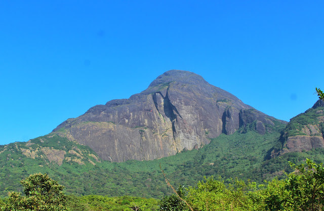
The forests around this peak are famous for the abundance of rare medicinal herbs and plants. It is also far away from human settlements, making it one of the pristine natural forests in Kerala. It hides one of the richest concentrations of biodiversity in the entire Western Ghats. Among the peaks of Western Ghats, Agasthyakoodam ranks as a medium peak. However, it has a magical aura around it and as you trek up the mountain, you feel refreshed and recharged. People believe that even the wind here has medicinal properties and will protect or cure you from diseases.Agasthyakoodam (also known as Agasthyarkoodam) is a 1868m tall mountain within the Neyyar Wildlife Sanctuary in Thiruvananthapuram district, Kerala. It lies on the border between Kerala and Tamilnadu. It is also known as Agasthyamala in Malayalam (അഗസ്ത്യമല) and Pothigai Malai in Tamil. This mountain belongs to the Ashambu Hills, the southern end of Western Ghats. There are over 25 peaks in Ashambu Hills and Agasthyakoodam peak is the tallest one among them.
One of the most interesting things about Agasthyakoodam is the rapid changes in landscape as you trek towards the peak. This trek will take you through moist deciduous forests, semi evergreen forests, grasslands and evergreen forests. Finally you will trek through dense evergreen forests and rock formations to reach Agasthyakoodam peak.
The original inhabitants of these hills are a tribe known as “Kanis” . Currently there are about 400 Kani families living around these areas. Kani settlements are located near the basins of streams of Karamanayar and Neyyar away from the core area of Agasthyakoodam. Some of the tribals work with eco-development committees organized by forest department. Recently they also started working as guides/staff for the Agasthyakoodam trek.
Agasthyakoodam Legends
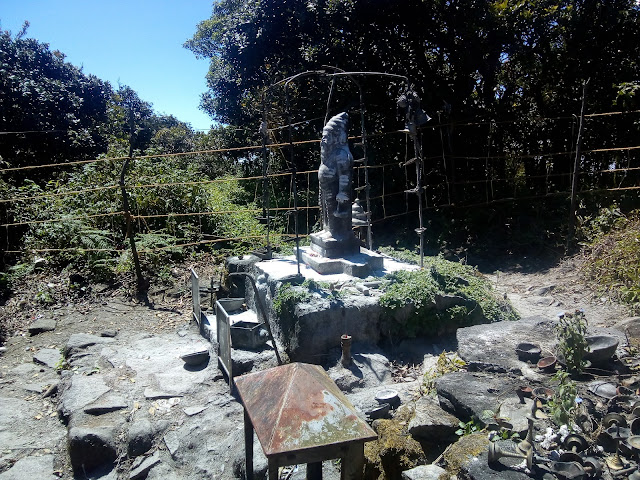
Agasthyakoodam peak is also a pilgrimage destination for Hindu devotees who believe that sage Agasthya meditated on the mountain. Sage Agasthya is one of the seven maharishis(Saptarishis) in Hindu puranas. There is a small shrine on the mountain top with an idol of Agasthya rishi and during Agasthyakoodam trekking season, people perform pujas here.
Agasthya sage is considered to be guru of Ayurveda system of traditional Indian medicine. Most of his statues depict him with a stone crusher in one hand and a bowl of medicines in the other. He is also considered as the father of Tamil literature and Siddha medicine.
According to one of the legends, Everyone including maharishis moved to Himalayas during the wedding of Lord Shiva and Parvathi. This caused the earth to tilt to one side and Lord Shiva asked Agasthya to go to south and balance the earth again. Agasthya came to the southern mountains and he liked the place and stayed on. There are plenty of other interesting legends about Agasthyamuni.
Biosphere reserves are sites established by various countries under the UNESCO (United Nations Educational Scientific and Cultural Organization) operated program called Man and the Biosphere (MAB). This program aims to create biosphere reserves to protect biological and cultural diversity of a region while promoting sustainable economic development. Agasthyamalai Biosphere Reserve (ABR) was established in 2001 under the UNESCO MAB program. This is a large site covering about 3500 square kilometres and spans across the forests of southern Kerala and Tamilnadu. The areas in Kerala under ABR include Neyyar wildlife sanctuary, Peppara wildlife sanctuary, Shendurney wildlife sanctuary, Achencoil, Thenmala, Konni, Punalur and Agasthyavanam biological park. Agasthyakoodam is the eastern boundary of Agasthyavanam biological park. On the eastern side Agasthyakoodam is protected by Mundanthurai tiger reserve (Tamilnadu).
Agasthyakoodam peak and surrounding areas are protected reserved forest under the control of Kerala Forest Department and entry is restricted. Forest department allows a controlled pilgrimage/trek during January to March of every year. This pilgrimage starts on the day of the Makaravilakku festival in Sabarimala temple and ends on the Sivarathri day. Usually this means that the trek will be available for about 60 days. Only 100 entry passes are issued each day of the trek and the entry passes are given on first come first serve basis.
Usually entry passes run out on the first day of the booking. Alternatively you can also trek to Agasthyakoodam during the offseason, but you need to pay more (Rs.4000+ for a team of 5). This article is focused on the trek experience during the pilgrimage season.
People attempt Agasthyakoodam trek with a wide range of interests. Some are interested in the physically demanding trek alone, some are interested in exploring the flora and fauna around and for some it is a pilgrimage. This article is a comprehensive guide to Agasthyakoodam trek including trekking tips, online booking information and what you can expect on the trek.
Note that children and women are not allowed for this trek. There are religious as well as practical reasons for this.
Till 2013, booking for Agasthyarkoodam pilgrimage trek was a tedious process. Usually a couple days before the start of the trekking program, forest department would publish the date for getting entry passes. The entry tickets were issued from the forest office in PTP Nagar, Trivandrum. People will queue up from midnight for getting the entry passes and there is a huge demand for passes for the weekends. The booking process involved 2 stages. In the first stage, you will need to find an available date and then a application form will be issued to you with the date of trek entered. Maximum of 3 persons were allowed in a single pass. You need to fill up the form with details of the trek team members including details of their identity proof documents. You also need to attach copies of the identity proof. Finally you will submit the form at a second counter and pay the fee. Forest department will issue the entry pass later that day or the next day. Needless to say, getting passes was a nightmare.
From this year (2014), you can book Agasthyakoodam trekking entry passes online! The link for booking trek tickets will be available on the official website of Kerala forest department on the opening day of booking. In 2014, this facility was rolled out through Kerala eService Delivery Portal and you can register an account for the portal anytime. For example, if the trek program starts on 15th January, the ticket booking will usually open on 12th January and the details of the dates would be published somewhere around 10th January in all major newspapers. Forest department website also provides a link for getting ticket availability status!
Up to 15 people can be booked on a single ticket and you need to pay Rs.500 per person. The trekking fee must be paid online, but only a limited number of banks are enabled for online money transfer. Before booking ensure that you have the following information available for each member of the trekking team,
Name, age and contact number
Type of identity proof (Aadhar, Driving License, Election Card etc.)
Identity proof number
Address
Once you book the ticket and pay the money you get an option to print the entry pass. Always save a copy of the ticket before you print it. You can also access the entry pass later by logging into Kerala eService Delivery Portal and then selecting View Status Application => Track Application Status option from the left menu of the homepage.
The entry pass also contains an affidavit which the team leader of the trekking group must sign. On the day of your trek, you need to report to Bonacaud forest station at 7AM with the entry pass/affidavit and the ID proof originals of all members of the trekking team.
Alternatively you can get tickets through Akshaya centres or by going to the PTP forest office in Trivandrum. They all use the same system and hence it would be wise to book on your own from the comfort of your home.
Following is the checklist I use whenever I go on the Agasthyakoodam trek (or for that matter any overnight trek). Since you will be most probably going as part of a team, there are things that only one member of the team needs to carry for the entire group. This is indicated separately (G) in the following checklist. Please note that alcohol is strictly banned and the forest staff will check your luggage for it when you report for the trek. Please read the notes after the checklist,
❑ A lightweight hat for sun protection
At the mountain peak, it may rain even during peak summer. Hence rain proof plastic bags are essential to protect your gear. Carry quality ones since you might have to convince the forest guards that you are not going to discard them along the trek.
A good hat is essential since sun will literally roast you when you cross the grasslands.
If you are trying to complete the trek in 2 days, a torch per participant is an absolute must. It would be dark by the time you return to Bonacaud.
Binoculars are heavy and carry it only if your group can share the load!
Bonacaud is a tiny village located about 50km from Thiruvananthapuram city. Bonacaud is the starting point for official Agasthyakoodam trek. If you are going from Trivandrum, you need drive through the Ponmudi road via Nedumangad and then after about 1km from Vithura town, you need to take a right turn. After you cross Vithura town look for directions to Bonacaud. Ensure that you start early since it would take about 2 hours to cover the 50km winding roads.
Buses are available till the Bonacaud village, however to reach at 7am you need catch the first bus. The forest office from where you begin the trek is located about 1km away from the bus stop. If you are taking the bus, you need to walk this distance. The road from Bonacaud village actually passes through the side of an abandoned tea factory and there is a gate at the entrance of this road. If you are taking your car or bike, you can open the gate and then head towards the forest office. Note that this road is in bad condition and unless you are an expert car driver or you have an SUV, I suggest you take the bike. During our last visit, we found that almost all the cars had some sort of damage after covering this rough road.
There is a small shop and a canteen at Bonacaud picket station. A toilet complex also is available right near the start of the trekking path. You can have your breakfast from the canteen and can also buy the packed lunch for the trek from here.

There is another canteen at Athirumala base camp. Canteen serves basic vegetarian food and tea/coffee. This canteen opens at 6am and closes at 8:30pm.
There are a number of forest camps along the trekking trail and are located near water streams. In case of emergency, you can approach them.
Trivandrum city to Bonacaud roadmap is given below,

The following map shows the trekking path from Bonacaud to Athirumala (waypoints indicated are explained in the tables given in trekking experience section),

The following map shows the climb from Athirumala to Agasthyakoodam peak,

Forests around Agasthyakoodam has a rich wildlife ecosystem. Even the Bonacaud entry point has plenty of wildlife. I think forest department scares away animals from the trek trail during the 2 month trekking season. Always be prepared for wildlife encounter especially in the morning and evening. Elephants may cross your path when you are near Athirumala camp. Elephants take this route to reach Peppara reservoir for water. We have also spotted bear droppings along the route between Athirumala and Agasthyakoodam peak. Keep your eyes open!
Agasthyakoodam area belongs to Neyyar wildlife sanctuary and Peppara wildlife sanctuary. There are around 43 species of mammals including tiger, leopard, sloth bear, elephant, sambar, barking deer, Nilgiri langur and Nilgiri tahr. It is also home to over 230 species of birds, 45 species of reptiles and about 40 species of fish.
As you trek towards the mountain peak, you will come across natural Bonsai trees! Trees around the peak are stunted due to the heavy winds lashing throughout the year. They are also often covered with lichens, mosses and ferns. You will also come across plenty of small insects along the trek trail.

Agasthyakoodam trek can be completed in 2 days or 3 days depending on your stamina and your interests. If you are looking to test the limits of your physical endurance and trekking is your main interest, I suggest you complete it in 2 days. If you are there to experience the forest or looking to explore the flora and fauna of the Agasthyakoodam, you need 3 days.
Between your starting point at Bonacaud and Agasthyakoodam peak, there is only one halting location. It is a small camp located at a place called Athirumala. It is located on the western valley of Agasthyakoodam peak and offers majestic views of the peak. Night stay here is safe since it is protected by trenches around it. The distance from Bonacaud starting point to Athirumala is around 15km and the distance from Athirumala to the mountain peak is around 5km. But note that during the 5km stretch you would be climbing almost 1000 metres.
Whether you are going on a 2 day or 3 day trek, the first phase is always the same. You will start around 8am from the Bonacaud forest office after the formalities and then head towards Athirumala. You can reach Athirumala anywhere between 2pm to 6pm depending on how fast you trek, whether you take a bath along the way etc. Cover this stretch in slow pace and enjoy the nature and the water streams along the way.
If you are completing the trek in 2 days, this is going to be a hectic day. You need to wake up around 5AM and get ready by 6AM. You then take a quick trek covering 5KM to the top. You should be on the top by around 10AM and need return by 11AM. You need reach Athirumala at 1PM and then after a quick lunch you need head back to Bonacaud by 2PM. Even then you need keep a steady fast pace to reach Bonacaud before nightfall (7PM).
If you are completing the trek in 3 days, you take the second day to visit mountain peak and return to Athirumala. On the 3rd day you can return back to Bonacaud just the same way you went to Athirumala. This gives you plenty of time to experience the forest, the mountain peak and the water streams along the way.
Warning: The following section is full of spoilers! I strongly suggest you to avoid this section if you like surprises during your trek.
We usually go for a 2 day trek since we are always looking for a tough trek. But we also want to experience what the forest has to offer. We have been doing this trek for three years consecutively and hence has fine tuned our trek. This section may help you in planning your trek as per your needs.
After the check-in formalities at the Bonacaud forest station, you will be leaving for the Athirumala base station at around 8:30am. The forest beat officer (BFO) in charge will give a quick introduction of the trek and would remind you that you are going through a forest full of wildlife. There will be a number of other groups along with you and you can expect an overall strength of 40 to 60 people in the first batch leaving Bonacaud. One or two forest guards (from local tribal population) will accompany you along. Soon the group will get split into multiple small groups since everyone walks at a different pace. Usually the forest guards will be in front accompanying the first group. You will also encounter forest guards walking in both directions for random surveillance along the trekking trail.

The initial part of the trek is through a think jungle with cool morning breeze flowing through it. If you look around you can get walking sticks left by earlier teams (These sticks can be a major help when you climb down from the peak on the next day). This stretch of around 4km consists of moist deciduous and semi evergreen forests and you will come across the Karamana river at the end of it. There is a small shrine dedicated to the mountain god (Maladevan) and a forest camp is located here.
The next stretch of about 5KM between Karamana river and Attayar river consists of semi evergreen forests and there are plenty of water streams along the way. Vazapaithiyar river is located somewhere in the middle of this stretch and it has an excellent waterfall for an energizing bath! Usually trekkers will have their lunch at Attayar river.

After Attayar river, you will be walking through grasslands for about 4KM. You will see a towering mountain range on the left and towards the middle of this stretch, you will get a glimpse of Agasthyakoodam on your front left. You will be passing through small forest patches spread across the grasslands and it offers a refuge from the merciless afternoon sun.

The final stretch to Athirumala involves a vertical climb through evergreen forests. When you reach Athirumala covering a total distance of around 14km, you will be rewarded with a majestic view of the Agasthyakoodam mountain!
The forest officer in charge will greet you and will ask for your entry pass. Show your entry pass at the canteen and they will issue sleeping mats (on twin sharing basis!) for you. Find a place for your sleeping mat in one of the temporary grass huts. Take rest, have a cup of hot tea and then take a bath in the stream located nearby on the eastern side! You can also walk to the southern side of the camp which leads to another grassland. From here you get a breath-taking view of the entire mountain range.

You need to buy food coupons at the Athirumala camp well in advance. Get your dinner coupon during tea time and then get your breakfast coupon during dinner. Similarly when you have your breakfast book your lunch. This is important since without prior booking/coupons you may not get any food from the canteen!
The following table summarizes the Bonacaud to Athirumala trek trail along with the distance walked, altitude and the time taken from the starting point at Bonacaud.
Next day wake up by 5am and get ready by 6am. Give the food coupons you have taken on the previous day and collect your breakfast parcel. Leave towards peak by 6:30am.
This initial stretch is through dense evergreen forests and you will be crossing a number of water streams. If you are lucky, you may come across monkeys, peacocks and elephants along this path. After walking for around 1.5km you will come across a giant rock on the right side. Climb on it to get a mesmerizing view of the valleys below and of the Agasthyakoodam peak. It is a perfect spot to have your breakfast and wait for the first sunrays to appear behind the peak.

It is easy to miss the trekking path along this stretch. Always look for yellow arrows marked on the rocks and it can be huge help in keeping you along the trek trail. During this stretch you will be crossing over to the eastern side of Agasthyakoodam. At around 2.5km, you will come across a huge rocky area with a small water stream running through the middle of it. Never walk too close to the cliff as the wind may throw you over it!
You need to cross over the stream and climb up on the other side. Then turn right and walk over the ridge to reach a huge open space. From here you get the entire view of Mundanthurai tiger reserve. This place is known as “Pongalappara” and devotees cook rice offerings here. Walk across this rocky plains and head to west to start your final climb to the peak (approximately 2km from here).

The temperature drops as you climb and and you will cross thick evergreen forests along this route. It is popularly known as “A/C Vanam” (A/C Forest). This place is treacherous during rainy season and as you reach towards the top, this climb becomes progressively difficult. Finally you will come across rocks which are nearly vertical. There are metal and plastic ropes available for the final climb. If you have fear of heights, climbing this would be tough.

As you look down, you will be blown away by the vastness of the valleys and the mountains below. You will also suddenly notice another majestic mountain range which seems to have magically appeared from nowhere! This mountain range of 5 peaks is known Ainthuthalai Pothigai.

As you reach the top, the first thing you notice is the ferocious winds at this height and if you are not careful, you might fall. Agasthya shrine/idol is located in the middle of a small forest on the peak and hence is protected from the wind. As you spend time here, you realize that you should have attempted this trek much earlier!
The following table summarizes the Athirumala to Agasthyakoodam Peak trek trail along with the distance and the average time taken from the starting point at Athirumala.
If you are on the 2 day trek, you need to climb down from the peak before 11:30am and even then you need hurry to reach Athirumala before 1:30pm. You will be able to spend about 1 hour on the top.
Ensure that you return before 2pm from Athirumala to Bonacaud. Even then you need to walk fast to cover the return distance before nightfall. If you plan to take a waterfall bath along the way, you should return by 1:30pm.
Never trek alone. Even if you are going alone, ensure that you are near another trek team. This is very important since animals such as bear may attack when you walk alone.
Always be alert and lookout for animals. Do not make loud noises. Animals such as elephants attack only when they are startled by close contact. So keep your eyes open.
Since you carry only one bottle of water, keep it filled whenever you get a chance. This is very important for the last stretch of the trek since water is rare on the top.
Keep an additional lightweight footwear (rubber sandals) in your bag. Most of the so called “trekking shoes” get damaged when you trek on rough terrain. You cannot trek barefoot unless you are used to it. Avoid the shoes getting wet.
When you are at Athirumala camp, it can be pretty cold and windy during the night. The grass huts are pretty basic, so you need jackets/blankets, socks etc. to keep you warm.
When you are at Athirumala camp, book your dinner during tea time and then book your breakfast during dinner. Similarly when you have your breakfast book your lunch. This is important since without prior booking you may not get food from canteen!
When you return from Athirumala, don’t forget to return your sleeping mats and collect your entry pass from the canteen.
Agasthyakoodam is a trekker’s paradise. It is a trek which will test your stamina, provide you with beautiful views of almost all types of forests and best of all you can relax in a waterfall when you are tired. Trekking through the forests full of herbal plants and trees rejuvenates you. Attempt this trek only if you are physically fit. And finally,
Agasthyamalai Biosphere Reserve
Biosphere reserves are sites established by various countries under the UNESCO (United Nations Educational Scientific and Cultural Organization) operated program called Man and the Biosphere (MAB). This program aims to create biosphere reserves to protect biological and cultural diversity of a region while promoting sustainable economic development. Agasthyamalai Biosphere Reserve (ABR) was established in 2001 under the UNESCO MAB program. This is a large site covering about 3500 square kilometres and spans across the forests of southern Kerala and Tamilnadu. The areas in Kerala under ABR include Neyyar wildlife sanctuary, Peppara wildlife sanctuary, Shendurney wildlife sanctuary, Achencoil, Thenmala, Konni, Punalur and Agasthyavanam biological park. Agasthyakoodam is the eastern boundary of Agasthyavanam biological park. On the eastern side Agasthyakoodam is protected by Mundanthurai tiger reserve (Tamilnadu).
Agasthyakoodam Trekking
Agasthyakoodam peak and surrounding areas are protected reserved forest under the control of Kerala Forest Department and entry is restricted. Forest department allows a controlled pilgrimage/trek during January to March of every year. This pilgrimage starts on the day of the Makaravilakku festival in Sabarimala temple and ends on the Sivarathri day. Usually this means that the trek will be available for about 60 days. Only 100 entry passes are issued each day of the trek and the entry passes are given on first come first serve basis.
Usually entry passes run out on the first day of the booking. Alternatively you can also trek to Agasthyakoodam during the offseason, but you need to pay more (Rs.4000+ for a team of 5). This article is focused on the trek experience during the pilgrimage season.
People attempt Agasthyakoodam trek with a wide range of interests. Some are interested in the physically demanding trek alone, some are interested in exploring the flora and fauna around and for some it is a pilgrimage. This article is a comprehensive guide to Agasthyakoodam trek including trekking tips, online booking information and what you can expect on the trek.
Note that children and women are not allowed for this trek. There are religious as well as practical reasons for this.
Agasthyarkoodam Trekking Online Booking
Till 2013, booking for Agasthyarkoodam pilgrimage trek was a tedious process. Usually a couple days before the start of the trekking program, forest department would publish the date for getting entry passes. The entry tickets were issued from the forest office in PTP Nagar, Trivandrum. People will queue up from midnight for getting the entry passes and there is a huge demand for passes for the weekends. The booking process involved 2 stages. In the first stage, you will need to find an available date and then a application form will be issued to you with the date of trek entered. Maximum of 3 persons were allowed in a single pass. You need to fill up the form with details of the trek team members including details of their identity proof documents. You also need to attach copies of the identity proof. Finally you will submit the form at a second counter and pay the fee. Forest department will issue the entry pass later that day or the next day. Needless to say, getting passes was a nightmare.
From this year (2014), you can book Agasthyakoodam trekking entry passes online! The link for booking trek tickets will be available on the official website of Kerala forest department on the opening day of booking. In 2014, this facility was rolled out through Kerala eService Delivery Portal and you can register an account for the portal anytime. For example, if the trek program starts on 15th January, the ticket booking will usually open on 12th January and the details of the dates would be published somewhere around 10th January in all major newspapers. Forest department website also provides a link for getting ticket availability status!
Up to 15 people can be booked on a single ticket and you need to pay Rs.500 per person. The trekking fee must be paid online, but only a limited number of banks are enabled for online money transfer. Before booking ensure that you have the following information available for each member of the trekking team,
Name, age and contact number
Type of identity proof (Aadhar, Driving License, Election Card etc.)
Identity proof number
Address
Once you book the ticket and pay the money you get an option to print the entry pass. Always save a copy of the ticket before you print it. You can also access the entry pass later by logging into Kerala eService Delivery Portal and then selecting View Status Application => Track Application Status option from the left menu of the homepage.
The entry pass also contains an affidavit which the team leader of the trekking group must sign. On the day of your trek, you need to report to Bonacaud forest station at 7AM with the entry pass/affidavit and the ID proof originals of all members of the trekking team.
Alternatively you can get tickets through Akshaya centres or by going to the PTP forest office in Trivandrum. They all use the same system and hence it would be wise to book on your own from the comfort of your home.
Checklist for Agasthyarkoodam Trekking
Following is the checklist I use whenever I go on the Agasthyakoodam trek (or for that matter any overnight trek). Since you will be most probably going as part of a team, there are things that only one member of the team needs to carry for the entire group. This is indicated separately (G) in the following checklist. Please note that alcohol is strictly banned and the forest staff will check your luggage for it when you report for the trek. Please read the notes after the checklist,
Agasthyakoodam Trekking Checklist (G indicates that it is only required for the entire group)
❑ A lightweight hat for sun protection
❑ A lightweight torch
❑ Emergency food/snacks (banana, apple?)
❑ One or two sets of spare dress
❑ Two lightweight bathing towels
❑ Two sets of socks and underwear
❑ One blanket and one lightweight bed sheet
❑ Lightweight 1 litre water bottle
❑ ID proof that you used for booking your entry pass
❑ Trekking shoes
❑ Spare set of footwear (rubber slippers)
❑ Agasthyakoodam trek entry pass
❑ Lightweight trekking bag
❑ Minimum cash of Rs. 500
❑ (G) A small pack of salt. Best defence against blood seeking leeches.
❑ (G) A small set of medicines including paracetamol, bandages etc.
❑ (G) Binoculars
❑ (G) 1 lightweight notebook and pen
❑ (G) A dedicated GPS device with spare battery. I use Garmin etrex 10.
❑ (G) Carry a multi-tool if you have one
❑ (G) Camera and spare battery. Since the trek takes 2 to 3 days, carry spare batteries.
❑ (G) 2 rain proof plastic bags
❑ (G) Quick fix and a small plastic rope
Notes on Trekking Checklist
There is plenty of water along the way. Hence you don’t need to carry too much water. However conserve your water during the last stretch of your climb and keep the bottle filled up whenever you get a chance.At the mountain peak, it may rain even during peak summer. Hence rain proof plastic bags are essential to protect your gear. Carry quality ones since you might have to convince the forest guards that you are not going to discard them along the trek.
A good hat is essential since sun will literally roast you when you cross the grasslands.
If you are trying to complete the trek in 2 days, a torch per participant is an absolute must. It would be dark by the time you return to Bonacaud.
Binoculars are heavy and carry it only if your group can share the load!
Getting to Bonacaud
Bonacaud is a tiny village located about 50km from Thiruvananthapuram city. Bonacaud is the starting point for official Agasthyakoodam trek. If you are going from Trivandrum, you need drive through the Ponmudi road via Nedumangad and then after about 1km from Vithura town, you need to take a right turn. After you cross Vithura town look for directions to Bonacaud. Ensure that you start early since it would take about 2 hours to cover the 50km winding roads.
Buses are available till the Bonacaud village, however to reach at 7am you need catch the first bus. The forest office from where you begin the trek is located about 1km away from the bus stop. If you are taking the bus, you need to walk this distance. The road from Bonacaud village actually passes through the side of an abandoned tea factory and there is a gate at the entrance of this road. If you are taking your car or bike, you can open the gate and then head towards the forest office. Note that this road is in bad condition and unless you are an expert car driver or you have an SUV, I suggest you take the bike. During our last visit, we found that almost all the cars had some sort of damage after covering this rough road.
Facilities Available
There is a small shop and a canteen at Bonacaud picket station. A toilet complex also is available right near the start of the trekking path. You can have your breakfast from the canteen and can also buy the packed lunch for the trek from here.
There is another canteen at Athirumala base camp. Canteen serves basic vegetarian food and tea/coffee. This canteen opens at 6am and closes at 8:30pm.
There are a number of forest camps along the trekking trail and are located near water streams. In case of emergency, you can approach them.
Location Map
Trivandrum city to Bonacaud roadmap is given below,
The following map shows the trekking path from Bonacaud to Athirumala (waypoints indicated are explained in the tables given in trekking experience section),
The following map shows the climb from Athirumala to Agasthyakoodam peak,
Agasthyakoodam Wildlife
Forests around Agasthyakoodam has a rich wildlife ecosystem. Even the Bonacaud entry point has plenty of wildlife. I think forest department scares away animals from the trek trail during the 2 month trekking season. Always be prepared for wildlife encounter especially in the morning and evening. Elephants may cross your path when you are near Athirumala camp. Elephants take this route to reach Peppara reservoir for water. We have also spotted bear droppings along the route between Athirumala and Agasthyakoodam peak. Keep your eyes open!
Agasthyakoodam area belongs to Neyyar wildlife sanctuary and Peppara wildlife sanctuary. There are around 43 species of mammals including tiger, leopard, sloth bear, elephant, sambar, barking deer, Nilgiri langur and Nilgiri tahr. It is also home to over 230 species of birds, 45 species of reptiles and about 40 species of fish.
As you trek towards the mountain peak, you will come across natural Bonsai trees! Trees around the peak are stunted due to the heavy winds lashing throughout the year. They are also often covered with lichens, mosses and ferns. You will also come across plenty of small insects along the trek trail.
Agasthyarkoodam Trek Overview
Agasthyakoodam trek can be completed in 2 days or 3 days depending on your stamina and your interests. If you are looking to test the limits of your physical endurance and trekking is your main interest, I suggest you complete it in 2 days. If you are there to experience the forest or looking to explore the flora and fauna of the Agasthyakoodam, you need 3 days.
Between your starting point at Bonacaud and Agasthyakoodam peak, there is only one halting location. It is a small camp located at a place called Athirumala. It is located on the western valley of Agasthyakoodam peak and offers majestic views of the peak. Night stay here is safe since it is protected by trenches around it. The distance from Bonacaud starting point to Athirumala is around 15km and the distance from Athirumala to the mountain peak is around 5km. But note that during the 5km stretch you would be climbing almost 1000 metres.
Bonacaud to Athirumala Basecamp Trek (Day 1)
Whether you are going on a 2 day or 3 day trek, the first phase is always the same. You will start around 8am from the Bonacaud forest office after the formalities and then head towards Athirumala. You can reach Athirumala anywhere between 2pm to 6pm depending on how fast you trek, whether you take a bath along the way etc. Cover this stretch in slow pace and enjoy the nature and the water streams along the way.
Athirumala Basecamp to Agasthyakoodam and Return to Bonacaud (Day 2/3)
If you are completing the trek in 2 days, this is going to be a hectic day. You need to wake up around 5AM and get ready by 6AM. You then take a quick trek covering 5KM to the top. You should be on the top by around 10AM and need return by 11AM. You need reach Athirumala at 1PM and then after a quick lunch you need head back to Bonacaud by 2PM. Even then you need keep a steady fast pace to reach Bonacaud before nightfall (7PM).
If you are completing the trek in 3 days, you take the second day to visit mountain peak and return to Athirumala. On the 3rd day you can return back to Bonacaud just the same way you went to Athirumala. This gives you plenty of time to experience the forest, the mountain peak and the water streams along the way.
Agasthyakoodam Trek Experience (2 Day Trek)
Warning: The following section is full of spoilers! I strongly suggest you to avoid this section if you like surprises during your trek.
We usually go for a 2 day trek since we are always looking for a tough trek. But we also want to experience what the forest has to offer. We have been doing this trek for three years consecutively and hence has fine tuned our trek. This section may help you in planning your trek as per your needs.
After the check-in formalities at the Bonacaud forest station, you will be leaving for the Athirumala base station at around 8:30am. The forest beat officer (BFO) in charge will give a quick introduction of the trek and would remind you that you are going through a forest full of wildlife. There will be a number of other groups along with you and you can expect an overall strength of 40 to 60 people in the first batch leaving Bonacaud. One or two forest guards (from local tribal population) will accompany you along. Soon the group will get split into multiple small groups since everyone walks at a different pace. Usually the forest guards will be in front accompanying the first group. You will also encounter forest guards walking in both directions for random surveillance along the trekking trail.
The initial part of the trek is through a think jungle with cool morning breeze flowing through it. If you look around you can get walking sticks left by earlier teams (These sticks can be a major help when you climb down from the peak on the next day). This stretch of around 4km consists of moist deciduous and semi evergreen forests and you will come across the Karamana river at the end of it. There is a small shrine dedicated to the mountain god (Maladevan) and a forest camp is located here.
The next stretch of about 5KM between Karamana river and Attayar river consists of semi evergreen forests and there are plenty of water streams along the way. Vazapaithiyar river is located somewhere in the middle of this stretch and it has an excellent waterfall for an energizing bath! Usually trekkers will have their lunch at Attayar river.
After Attayar river, you will be walking through grasslands for about 4KM. You will see a towering mountain range on the left and towards the middle of this stretch, you will get a glimpse of Agasthyakoodam on your front left. You will be passing through small forest patches spread across the grasslands and it offers a refuge from the merciless afternoon sun.
The final stretch to Athirumala involves a vertical climb through evergreen forests. When you reach Athirumala covering a total distance of around 14km, you will be rewarded with a majestic view of the Agasthyakoodam mountain!
The forest officer in charge will greet you and will ask for your entry pass. Show your entry pass at the canteen and they will issue sleeping mats (on twin sharing basis!) for you. Find a place for your sleeping mat in one of the temporary grass huts. Take rest, have a cup of hot tea and then take a bath in the stream located nearby on the eastern side! You can also walk to the southern side of the camp which leads to another grassland. From here you get a breath-taking view of the entire mountain range.
You need to buy food coupons at the Athirumala camp well in advance. Get your dinner coupon during tea time and then get your breakfast coupon during dinner. Similarly when you have your breakfast book your lunch. This is important since without prior booking/coupons you may not get any food from the canteen!
The following table summarizes the Bonacaud to Athirumala trek trail along with the distance walked, altitude and the time taken from the starting point at Bonacaud.
| Distance (KM) | Time From Origin (hour: minute) | Altitude in Metres | Landmark/Waypoint |
| 0.00 | 00:00 | 583 | Bonacaud forest office. Usually starts at 8:30am. |
| 1.51 | 00:30 | 578 | A small shrine of Agasthyamuni and forest guard tent (second camp since Bonacaud picket station) are located here. Earlier this camp used to be at Lathimotta protected by trenches. |
| 1.93 | 00:40 | 620 | This place is called Lathimotta. There is a diversion here towards Bonaforce waterfalls. This diversion is now closed to trekkers. |
| 2.19 | 00:50 | 631 | This is an ideal location for bird watching. If you plan for it, I suggest you reach this location as early as possible. |
| 2.58 | 01:00 | 665 | Now you are in the thick forest and the early sunlight sweeping in through the canopy gives a magical experience. |
| 3.29 | 01:10 | 649 | There is a large white tree close to trek path. We always halt here for photos. |
| 4.08 | 01:30 | 617 | You will cross the the mighty Karamanayar river here. You may halt here for a quick dip. The third forest guard tent is located here. There is also a small shrine of mountain god (Maladevan) under a huge tree. |
| 4.92 | 01:50 | 618 | This is an interesting stretch with dark open spaces with a number of large rocks. While returning you will reach here late and hence the place may seem scary. My biggest fear is an elephant standing in the disguise of a rock! |
| 5.08 | 01:55 | 615 | Now you are in an open area with plenty of sunlight. You can also see grasslands far away! |
| 5.83 | 02:20 | 572 | There is a diversion you can take at this stretch for a beautiful view. Climb up to your left for about 100m for excellent views of the mountains on the left. |
| 6.19 | 03:05 | 572 | You will cross the second river here known as Vazapaithiyar. It has a decent waterfall and we always halt here for a bath. The fourth forest camp is located here. [Halt : 30 minutes] |
| 8.16 | 04:00 | 554 | You can see grasslands to your right. |
| 8.63 | 04:15 | 585 | You will cross a small water stream here. |
| 8.90 | 04:20 | 562 | You will cross another small water stream here. |
| 9.19 | 04:27 | 572 | This is the last river (Attayar) you come across during your trek to Athirumala. Halt here for a dip in the water. This is also an ideal location for having your packed lunch. Fifth and the last forest camp before Athirumala base camp is also located here. Ensure that you fill your water bottles from here since water may be scarce till Athirumala. [Halt: 30 minutes] |
| 10.01 | 05:05 | 599 | You are now in the grasslands and the early climb has some excellent spots for bird watching. The mighty mountain range on your left side stretches up to Agasthyakoodam. Now you will thank me for advising you to get a good hat! |
| 10.44 | 05:20 | 652 | At this stretch of grasslands you can see the Agasthyakoodam peak far away in front of you to the left. |
| 10.90 | 05:30 | 693 | There are small forest stretches you need to cross even when you are in grasslands. This is the first forest crossing. |
| 11.61 | 05:50 | 769 | Usually there is a decent water stream here. Fill up your water bottles only if there is sufficient water flow in the stream. [Halt: 5 minutes] |
| 11.84 | 06:00 | 789 | This is the second forest stretch along the grasslands. |
| 12.43 | 06:30 | 867 | This is the end of the grasslands and it is time for the final climb to the base camp. You are now tired and this steep climb will test your stamina. Now you will be entering thick forests. Please be aware that elephants frequently cross this path. |
| 12.51 | 06:35 | 875 | If you are lucky, you might find a water stream here. |
| 13.25 | 07:05 | 1006 | The climb is over and you are almost there. From here take a left turn to head towards Athirumala camp. Please be aware that elephants frequently cross this path. |
| 14.13KM | 7 hours 40 minutes | 1023 metres | Now you are at the Athirumala camp. The forest officer in charge will greet you and will ask for your entry pass. Show your entry pass at the canteen and they will issue sleeping mats (on twin sharing basis!) for you. Find a place for your sleeping mat in one of the huts. Take rest, have a cup of hot tea and then take a bath in the stream located nearby! |
Next day wake up by 5am and get ready by 6am. Give the food coupons you have taken on the previous day and collect your breakfast parcel. Leave towards peak by 6:30am.
This initial stretch is through dense evergreen forests and you will be crossing a number of water streams. If you are lucky, you may come across monkeys, peacocks and elephants along this path. After walking for around 1.5km you will come across a giant rock on the right side. Climb on it to get a mesmerizing view of the valleys below and of the Agasthyakoodam peak. It is a perfect spot to have your breakfast and wait for the first sunrays to appear behind the peak.
It is easy to miss the trekking path along this stretch. Always look for yellow arrows marked on the rocks and it can be huge help in keeping you along the trek trail. During this stretch you will be crossing over to the eastern side of Agasthyakoodam. At around 2.5km, you will come across a huge rocky area with a small water stream running through the middle of it. Never walk too close to the cliff as the wind may throw you over it!
You need to cross over the stream and climb up on the other side. Then turn right and walk over the ridge to reach a huge open space. From here you get the entire view of Mundanthurai tiger reserve. This place is known as “Pongalappara” and devotees cook rice offerings here. Walk across this rocky plains and head to west to start your final climb to the peak (approximately 2km from here).
The temperature drops as you climb and and you will cross thick evergreen forests along this route. It is popularly known as “A/C Vanam” (A/C Forest). This place is treacherous during rainy season and as you reach towards the top, this climb becomes progressively difficult. Finally you will come across rocks which are nearly vertical. There are metal and plastic ropes available for the final climb. If you have fear of heights, climbing this would be tough.
As you look down, you will be blown away by the vastness of the valleys and the mountains below. You will also suddenly notice another majestic mountain range which seems to have magically appeared from nowhere! This mountain range of 5 peaks is known Ainthuthalai Pothigai.
As you reach the top, the first thing you notice is the ferocious winds at this height and if you are not careful, you might fall. Agasthya shrine/idol is located in the middle of a small forest on the peak and hence is protected from the wind. As you spend time here, you realize that you should have attempted this trek much earlier!
The following table summarizes the Athirumala to Agasthyakoodam Peak trek trail along with the distance and the average time taken from the starting point at Athirumala.
| Distance (KM) | Time From Origin (hour: minute) | Altitude in Metres | Landmark/Waypoint |
| 0.00 | 00:00 | 1023 | Athirumala base camp. |
| 0.20 | 00:10 | 1036 | Take the right turn towards Agasthyakoodam. Pilgrims perform worship at this junction. |
| 1.01 | 00:35 | 1109 | Small stream of fresh water which passes through the eastern side of base camp. The forest here is thick and there is plenty of medicinal plants along the way. |
| 1.42 | 00:50 | 1127 | Another water stream along the way. |
| 1.67 | 01:00 | 1175 | There is a giant rock on the right side which you can climb. This offers breath taking views of the valleys below. Wait here to watch the magic of sun rising behind Agasthyakoodam peak! You can also see Athirumala base camp from here. [Halt: 15 minutes] |
| 2.35 | 01:50 | 1323 | Another rocky area perfect for some rest! Note that this is bear territory, so always walk in a group. |
| 2.62 | 02:05 | 1349 | This is vast expanse of rocks with a small stream and a small fresh water pond. Devotees usually take a bath from here. This is the last source of fresh water, so fill your water bottles! From here you need to climb to the left. |
| 2.83 | 02:15 | 1404 | The climb leads to a ridge which separates Tamilnadu from Kerala. Mobile phone signals are available here. From here you can see the vast forest ranges of Mundanthurai tiger reserve. |
| 3.33 | 02:30 | 1447 | This is last valley before the final climb to the peak. Devotees perform a form of worship known as “Pongala”. This involves cooking of a rice based dessert called “Payasam”. This place is popularly known as “Pongalappara” (Pongala Rock). |
| 3.74 | 02:55 | 1527 | This is one of the first treacherous rock formations. The trek becomes difficult from this point. |
| 4.28 | 03:20 | 1683 | This is first near vertical climb over the rocks. During rainy season, it is almost impossible to climb above this section. In some places you might need to crawl up. |
| 4.70 | 03:50 | 1837 | This is the second and the last steep climb. There are steel ropes and plastic ropes here for support. Alternately you can crawl up! |
| 4.80KM | 4 hours | 1849 metres | Now you are the Agasthyakoodam peak! You will find the idol Agsthyamuni surrounded by short trees which protects it. The wind on the top at times is very strong and be careful when you walk around. Enjoy the breath-taking views of the valleys and the mountains all around! |
If you are on the 2 day trek, you need to climb down from the peak before 11:30am and even then you need hurry to reach Athirumala before 1:30pm. You will be able to spend about 1 hour on the top.
Ensure that you return before 2pm from Athirumala to Bonacaud. Even then you need to walk fast to cover the return distance before nightfall. If you plan to take a waterfall bath along the way, you should return by 1:30pm.
Agasthyakoodam Trekking Tips
Attempt Agasthyakkoodam trek only if you are physically fit. This is very important since you will be trekking through tough terrain for 50km in 2/3 days.Never trek alone. Even if you are going alone, ensure that you are near another trek team. This is very important since animals such as bear may attack when you walk alone.
Always be alert and lookout for animals. Do not make loud noises. Animals such as elephants attack only when they are startled by close contact. So keep your eyes open.
Since you carry only one bottle of water, keep it filled whenever you get a chance. This is very important for the last stretch of the trek since water is rare on the top.
Keep an additional lightweight footwear (rubber sandals) in your bag. Most of the so called “trekking shoes” get damaged when you trek on rough terrain. You cannot trek barefoot unless you are used to it. Avoid the shoes getting wet.
When you are at Athirumala camp, it can be pretty cold and windy during the night. The grass huts are pretty basic, so you need jackets/blankets, socks etc. to keep you warm.
When you are at Athirumala camp, book your dinner during tea time and then book your breakfast during dinner. Similarly when you have your breakfast book your lunch. This is important since without prior booking you may not get food from canteen!
When you return from Athirumala, don’t forget to return your sleeping mats and collect your entry pass from the canteen.
Summary
Agasthyakoodam is a trekker’s paradise. It is a trek which will test your stamina, provide you with beautiful views of almost all types of forests and best of all you can relax in a waterfall when you are tired. Trekking through the forests full of herbal plants and trees rejuvenates you. Attempt this trek only if you are physically fit. And finally,


I read all the information you have mentioned about things to do in Denver in your blog that is really commendable. I really like your post, please share more information with us.
ReplyDeleteExtremely useful information which you have shared here about disneyland paris by coach. This is a great way to enhance knowledge for us, and also beneficial for us. Thank you for sharing an article like this.
ReplyDelete